For me, Harvey began on August 13th as a tropical wave coming off of Africa. No big deal. This happens often each Hurricane season. It was the standard, ‘we have a new tropical wave to watch, X chance to develop, we’ll keep watching it’, and I went about my day. This tropical wave eventually became a tropical storm; officially named Harvey on August 17, east of the Caribbean Sea. At this point, still not a threat. The forecast for Harvey was to enter the Caribbean, interact with wind shear, and fall apart over the weekend (this is the weekend before it hit Rockport). Harvey did in fact fall apart, becoming a dis-organized tropical wave on Saturday, August 19; 6 days before its eventual landfall in Rockport. After not being worried about it over the weekend, I did my normal check up on the weather Sunday night before bed, and that was my first inkling that something was up. Something was going to be different with this system and I needed to change my message on Monday. That’s where my perspective of Harvey changes.
I came in to work on Monday, August 20, with a very different message than I left with on Friday. This system was going to impact the Coastal Bend. I was raising the ‘heads up’ flag that something was coming. Did I know how strong? No. I just knew it would be SOMETHING. I remember the social media feedback being overwhelmingly negative. Things like ‘these never come here, yeah right, fake news, etc.’, but the data said otherwise. At this point, the forecast was for this tropical wave to reorganize into a weak tropical storm or outside chance at a low end hurricane by the time it reaches the Texas Gulf Coast.
Tuesday, with a lack of aircraft reconnaissance gathering data from inside the system, now coming off of the Yucatan Peninsula, weather guidance was still fairly modest on the intensification of soon to be Harvey – a tropical storm or low end Cat 1 hurricane. To me, it looked like a rain maker, it had to be watched, but I still wasn’t crazy concerned about it, given forecast model data. I even squeezed a round of golf in on Tuesday afternoon. I wouldn’t golf again until September (I golf a lot).
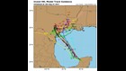
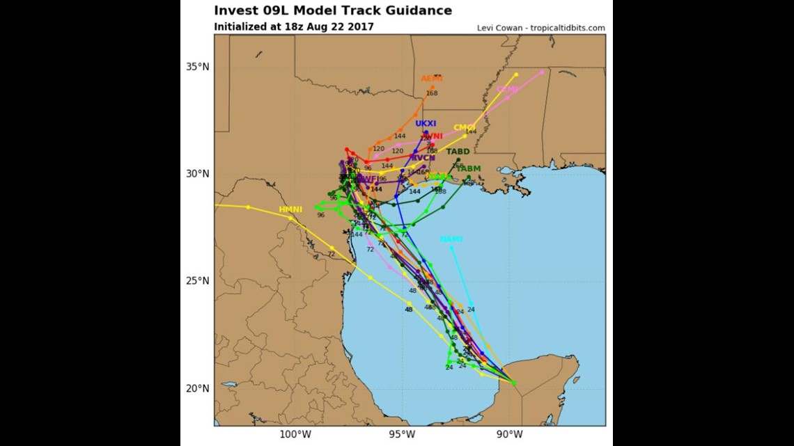

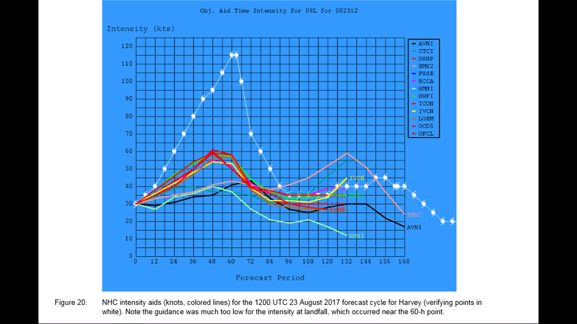
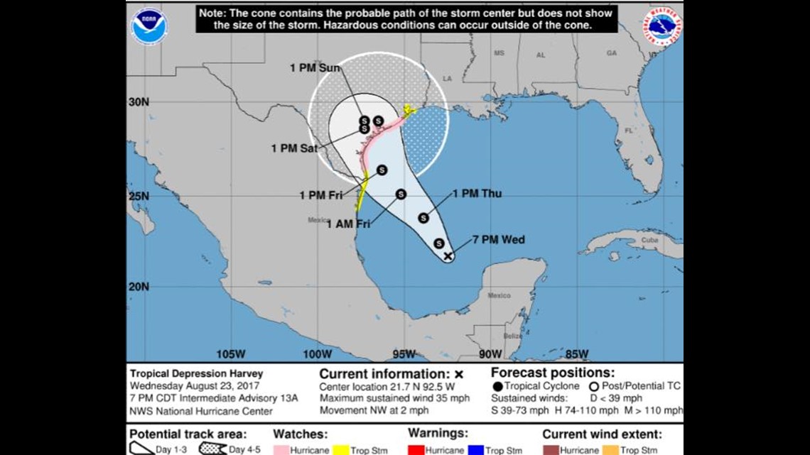
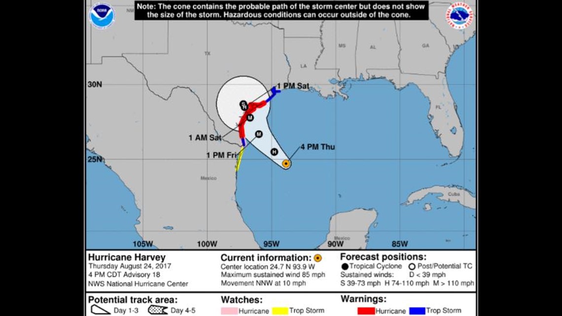
Wednesday. This is when forecasts got more threatening/serious. With new data coming in from aircraft in the storm, models were showing and indicating a stronger system coming in and the tracks was starting to become more clear that it was headed to the Coastal Bend. Still, not an exact track and the forecast intensity was still way below what would eventually happen. Staffing at channel 3 started ramping up and more dedication was being given to approaching Harvey, which as of Wednesday, was now a tropical storm. From this point on, the intensity forecast continued to ramp up and the storm, between Wednesday and Friday ramped up to category 4 status by Friday before landfall. A rapid intensification.
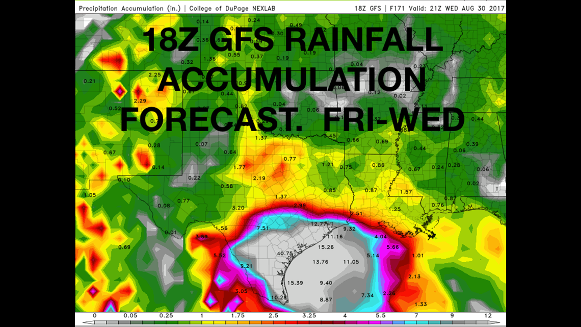
From a work perspective, I don’t remember a whole about Thursday, other than working 12 hours and updating to social media A LOT. Another part of the development of this storm was the slow movement that was expected AFTER it made landfall. I was concerned about the massive amount of rain Harvey was going to deliver, and it was looking like it would fall somewhere in the Coastal Bend. With how much Harvey strengthened, the big rains ended up falling in the Houston area, but leading up to the landfall, I was thinking rain on that level was not completely out of the question locally. I shared an image of the GFS weather model, which was printing a wide swatch of 40” of accumulated rain in the coastal bend somewhere and let me tell you….I still have never seen the level of flack that post received. It was astonishing. I knew 40” of rain was a lot. Catastrophic amount. I knew it would be looked at as sensationalist, because how could it not? But I posted it. And guess what? That forecast total was UNDERDONE by 20”!! The part of that forecast that was incorrect was the location of where that rain fall. Due in part to the rapid intensification and how Harvey moved after landfall. At that point, there was no way to know. But the potential was there.


Friday. It’s landfall day. All hands on deck at KIII. No one was leaving. It was a 22 hour day for me – 2AM to Midnight – and I won’t ever forget it. It was all about making sure people had enough information to be able to make an educated decision on whether to stay or leave. By this point, it was apparent that Rockport was in the cross-hairs for the worst of what Harvey had. I knew people there needed to get out. The mayor of Rockport was saying things along the lines of – if you are staying to ride out the storm, write your social security number on your forearm with sharpie so we can identify you after the storm. Basically, if you stay, you die. Wow. And he wasn’t wrong. So it was very clear that people in Rockport should be gone. Port Aransas too. The message was clear – get out of town. Evacuate. For me, those locations weren’t the problem from a messaging stand point. I knew what needed to be done there. The harder thing to communicate was what people in Corpus Christi needed to do.
Corpus Christi was right on the edge of the threshold of…we could get the eye wall or it could miss us too far to the north to really see any damaging effects. While I was on the air on Friday morning, model data was still indicating that the eye wall, the most damaging part of a hurricane, could still clip parts of Corpus Christi. That scared me. It wasn’t completely out of the question that Corpus Christi received winds over 100 mph. Looking back, those 100mph+ winds were only 20 miles away in Port Aransas. That’s nothing from a meteorological perspective. Still to this day, I am surprised that the damaging wind field did not extend into Corpus Christi. We were lucky. Very lucky. Back to reality; when I saw the possibility of the eye wall clipping Corpus Christi, I called my colleague at the National Weather Service to ask what they were doing with their families – many of them living in the Corpus Christi area. The answer was – ‘they’re gone’. That was enough for me. I went on air with the message that if it were me, I would be leaving, given the risk. I know everyone is different and has different needs, capabilities, resources, family size. I know this. But for me, I would have left. And that was my message, considering X, Y, and Z. My decision to say this was a complicated one because the messaging coming from Corpus Christi officials was not as clear, putting me in a difficult position. In Rockport, you have someone saying to sharpie your social security number on your forearm and 30 miles away, in Corpus Christi, the message was a lot more vague. You can see the messaging dilemma I had. I chose to err on the side of caution. If Corpus Christi were to get 100+ mph winds, it would be bad (we actually ended up getting 87 mph on the Oso Bay). If it missed, power would probably be out for the weekend (and it was). So, why stay? For me, I would leave. And that was my message. A message that numerous people have told me, saved their lives.

During the mid-day hours of Friday, I quickly ran to my apartment and gathered my essentials. I thought my apartment would be a lot different the next time I saw it, being on the Oso Bay. So I also put my valuables in my golf case and put it in an interior closet. I rushed back to the station, around 4pm and the winds were already picking up. At this point, Harvey was reaching Category 3 or 4 status – a major hurricane. And it was headed for the KIII viewing area. A lot of what happens between 4pm and midnight is a blur because of the shear amount of coverage, social media posting, facebook lives, everything going on. I do remember trying to illustrate how far out from the eye hurricane force winds extended for those that stayed in Corpus Christi. But my main focus was trying to talk people that may have stayed in Rockport/Port Aransas through the storm. How to take shelter and where. I tried to rattle off as many specific locations as I could recall to relay information about exactly where winds would be the worst and the worst damage would be. I knew it was going to be bad and that these communities would not be the same when the sun came up the next day. I answered thousands of questions on social media, as this event became a world news maker and it was happening here; my area of responsibility.
When I was relieved of my on-air duties, I did a quick facebook live on my private facebook page to let my family and friends no I was ok. There were SOOO many texts that had gone unanswered through the day from people asking if I was ok and what was going on that I simply could not answer. I remember being 100% drained and 110% drained emotionally. I went to the Domingo Live sofa, made a few phone calls and went to bed, with a call time of 4am Saturday….now about 3 hours away. There was a staffing error and all 3 meteorologists were ready to work. At this point, we didn’t need all of us, so I was sent home until 10AM, Saturday.
The drive home to my apartment is one of my most vivid memories of the whole ordeal. I was 4am. It was dark. There was no power. There was not a single car on the road and there were enough palm fronds on the road to rival a busy afternoon on SPID. But it was extremely eerie. I arrive at my apartment fearing the worst. The apartment directly above and below mine had their windows blown out. Mine were intact. I thought, there is no way the windows facing the Oso are still there if these windows are blown out. They were. No windows broken for me. So I lit some candles and took a cold shower, sleeping like a baby for a few hours. This, despite wind still blowing lose items around and an occasional sound of some glass breaking. I slept and I will never forget the feeling of that sleep.
Saturday was about learning what happened. The photos of damage and the aftermath. There was a time where I was the only person on air at KIII from about 10am to noon. I was reading news, covering weather, interviewing city officials, reporting on closures/openings – solo for 2 hours. That’s how I remember Saturday. At this point, much of Corpus Christi was without power, expect for a few areas. One of those areas was Chili’s on SPID. I ate there off of a paper plate and limited menu with a close friend of mine that works with Nueces County. We recounted our perspectives of what had just happened. Before we could finish our meals, the manager came over to us and said ‘this one’s on us’. I was grateful and I think that’s the first time I realized the magnitude of what had just happened. There was a group of AEP linemen next to me and I hope they got the same treatment because those guys worked their tails off for weeks after. Thankfully, the way Harvey was oriented after landfall, it brought cooler air down to the Coastal Bend, bringing some nice weather, considering we were in the middle of Summer. That little gesture from Chili’s is what I saw throughout the Coastal Bend for days and weeks after Harvey. Caring generosity given to people that didn’t know each other because it was the right thing to do.
I hope something like that never comes here again, but if it does, I will be ready and more experienced. Harvey taught me many lessons in communication, preparation, and tone. I will always error on the side of caution with hazardous weather. I know that a forecast can and will change. I will trust my knowledge of weather. And most importantly, I will do my best to inform people looking to me for information. Informing is different than hyping. It’s letting someone know what’s out there. What’s possible within reason. And that is how I remember Harvey.