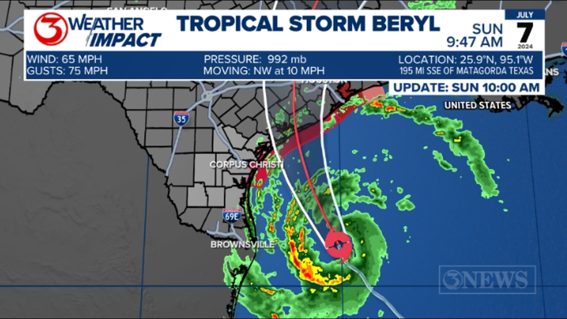
CORPUS CHRISTI, Texas — JULY 7, 10am – Beryl is beginning to take shape and we can now see the center of Beryl from the Brownsville radar. Current wind speed is 65 mph with gusts up to hurricane force; 75 mph. Movement is 12 mph to the NW. Beryl is less than 200 miles south of Matagorda Bay.

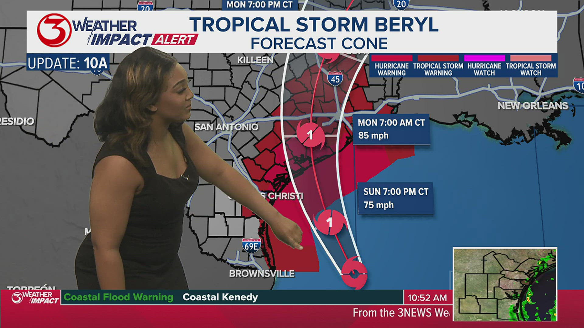
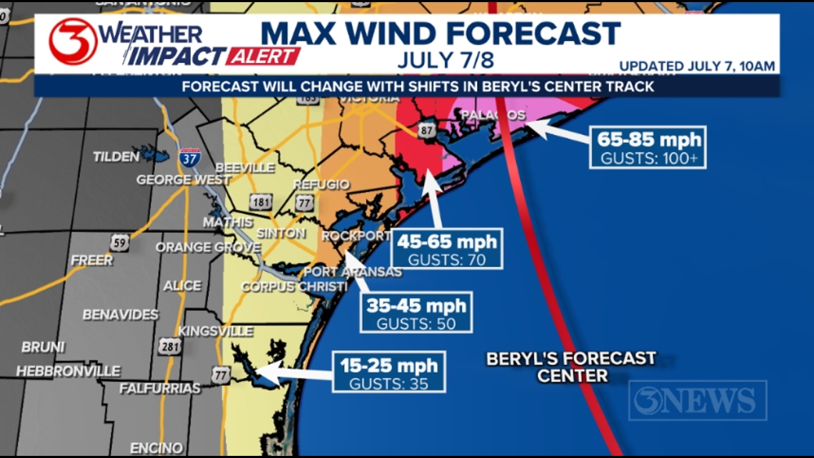
The July 7, 10am forecast cone continues to point to a landfall in the Matagorda Bay area near Palacios. Beryl is forecast to be a category 1, 85 mph hurricane by landfall overnight, into Monday morning. Wind gusts over 100 mph are possible. Most of the KIII viewing area is now west of the cone as the eastward shift in track we’ve been talking about for almost a week now continues. The current forecast cone extends as far west as Seadrift and Victoria. Based on the center line, Beryl will pass by Corpus Christi around 80 miles to the east tonight.

Rapid intensification is still possible prior to landfall. RI is defined as a 35 mph increase in wind speed within 24 hours. That would mean that sustained winds would need to be clocked at 95 mph for it to be considered rapid intensification. If I were in the Matagorda Bay area or slightly east of there, I would now be bracing for a category 2 hurricane.
WIND: The wind threat is far lower for most of the area, given the current center track. However, parts of the KIII viewing area may still be in line for lower grade tropical storm force conditions later today and tonight – Eastern Refugio, Eastern San Patricio, and Aransas Counties. A few gusts could also approach 40 mph on Mustang and North Padre Islands. The destructive wind threat will be focus around landfall, which looks to be the Matagorda Bay area.

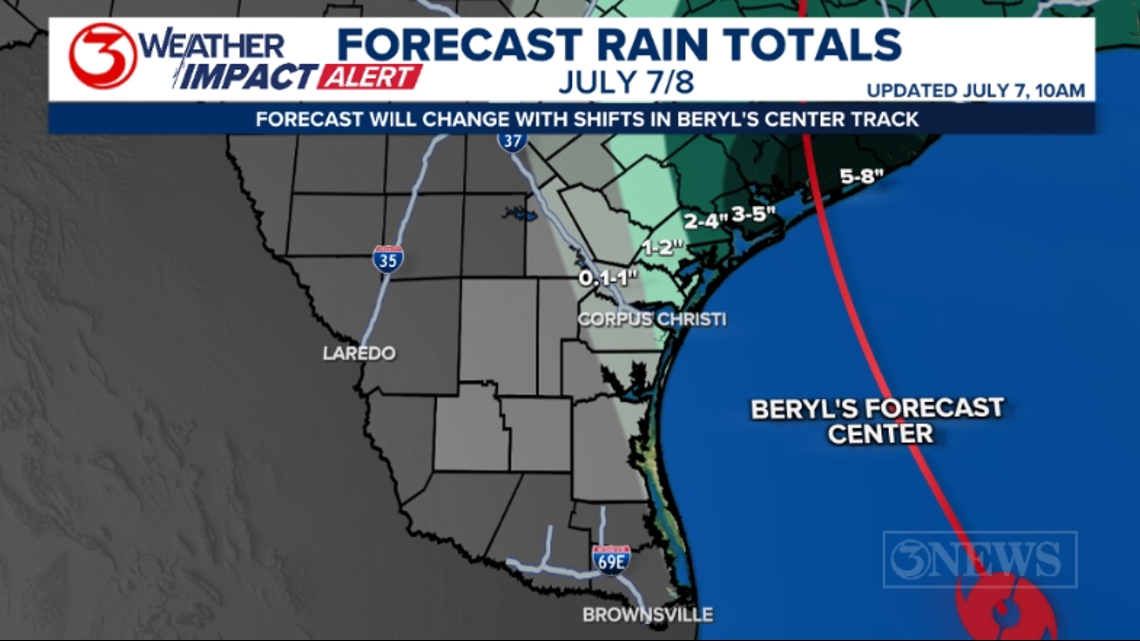
RAIN: With the east shift, the bulk of the rain will also be east. The Brush Country probably won’t see anything. Over half a foot near the center and east of the storm with totals quickly ramping down to the west and south of where Beryl moves in.

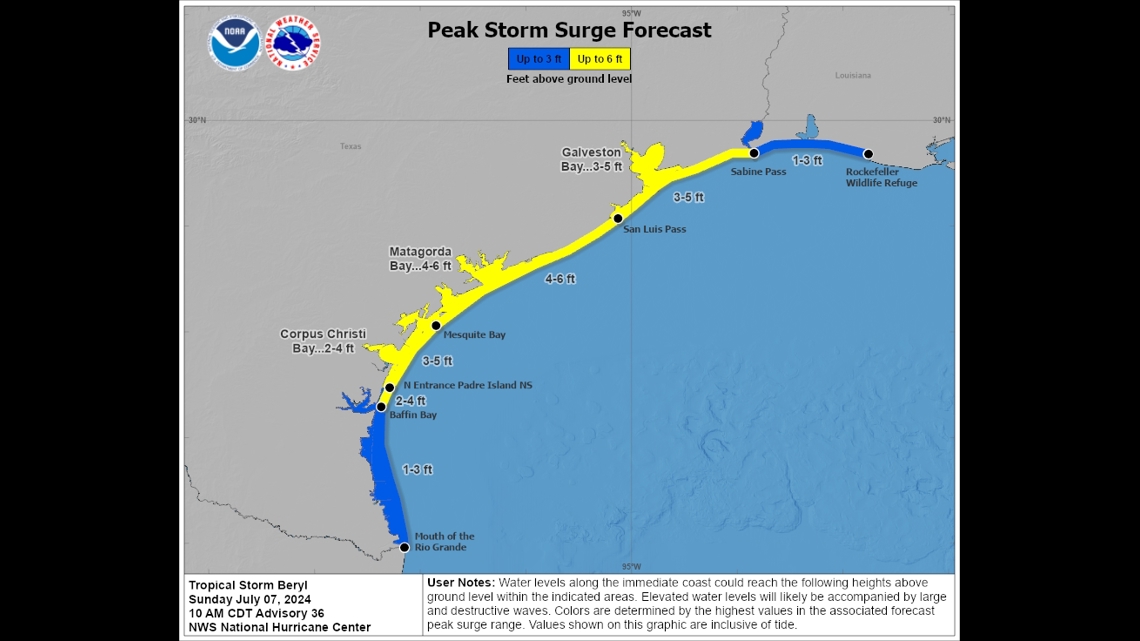
SURGE: The surge forecast is still at 3-5 ft on Coastal Bend beaches. Now down to 2-4 ft. in Corpus Christi Bay, and 1-3 ft. at and south of Baffin Bay. 4-6 ft. surge in Matagorda Bay. As Beryl moves by, the winds will be more out of the north and even northwest, which will mean an off-shore flow. That should help lower the surge. As Beryl passes by, wave heights will grow to around 6-8 ft. on area beaches this afternoon and night. Buoy data is showing 10 ft. waves off-shore.

The phrase I’ve been using ‘minor shifts in track can lead to big changes in impacts’ is a very real thing. In this case, those changes are working in our favor, while things have escalated rather quickly for the Matagorda Bay area as that part of the TX Gulf Coast is now bracing for a hurricane tonight. We will continue to be vigilant and highly in tune to any changes between now and landfall, even though the threat in the KIII viewing area is lower as of this writing.

Make sure to check out the 2024 KIII Hurricane Special - you can watch it (or re-watch) it here! The special includes topics like evacuations, hurricane kits, and rip currents - on top of information like the tropical outlook and new data on hurricane-related fatalities. You don't want to miss it!
For more on our local weather, head on over to our forecast post.
-------------------------------------------------------------
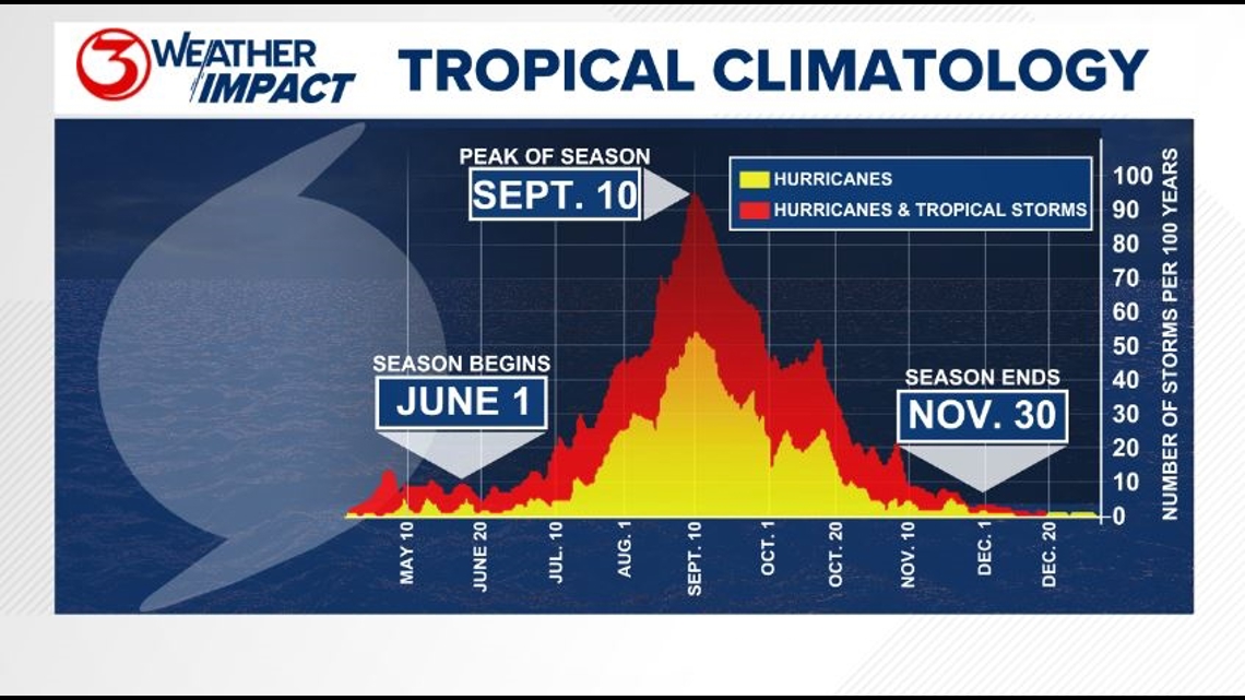
The Atlantic Hurricane Season runs from June 1 to November 30, with the peak of the climatological peak of the season happening on September 10.

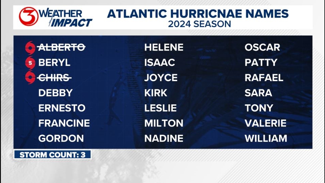
Here are the names for the 2024 Atlantic Hurricane Season. Names are given to tropical cyclones (tropical storms and hurricanes).

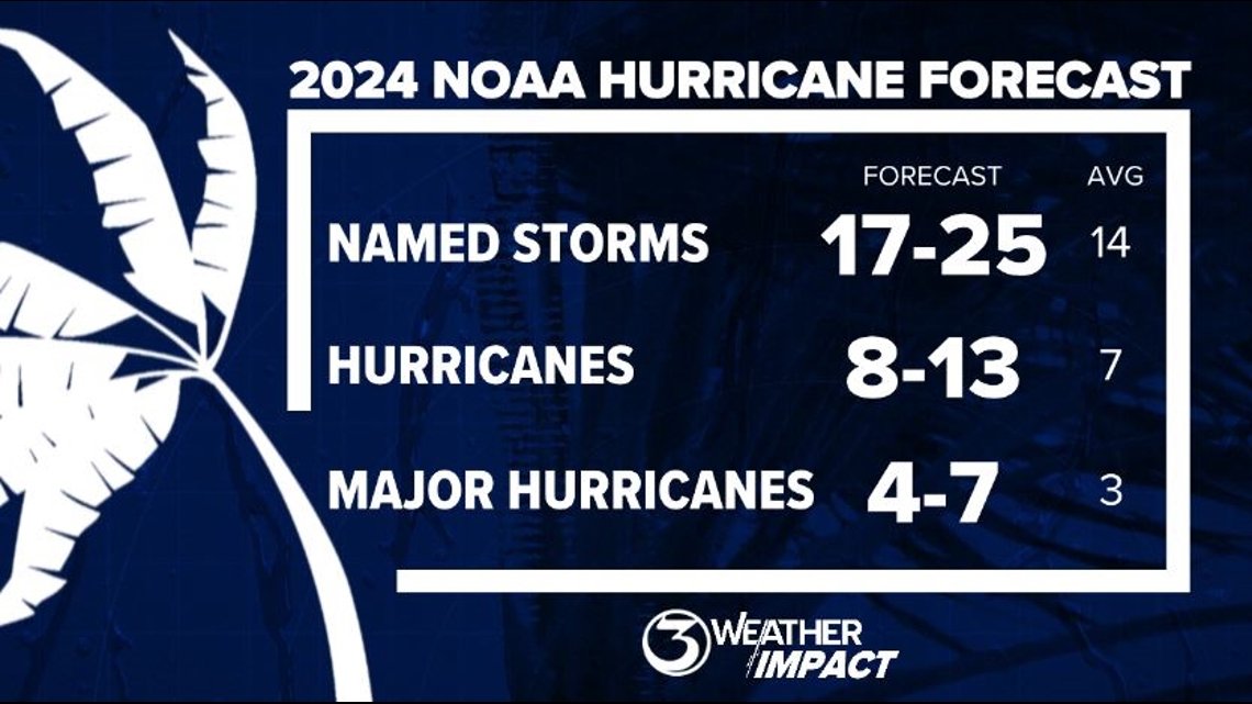
On May 23, NOAA released their forecast for the 2024 Atlantic Hurricane Season. They're predicting an above-average year, with 17-25 named storms. This is the highest pre-season forecast they've ever issued.
The high number of storms forecast is due to near-record sea surface temperatures and the return of La Nina, both of which favor tropical cyclone development. We talk more about those in our Hurricane Special, which you can watch here!

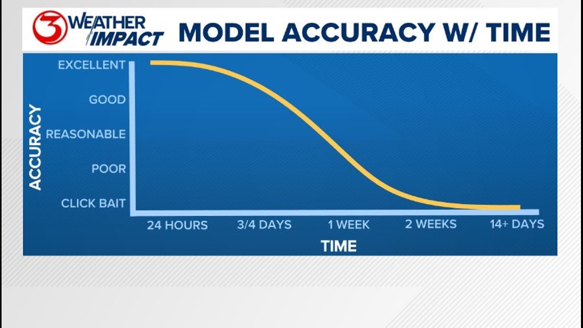
Remember to not "anchor" to the first forecast you see - forecasts change. Also, rely on a credible source for your tropical information and forecasts.