CORPUS CHRISTI, Texas — The tropics are certainly active and this should not come as a surprise, with all of the forecasts leading into the 2020 season calling for an above active year. Now that we are in late August and on the cusp of September, historically, this is the time when the tropics tend to come alive.
WATCH THE LIVE QUESTION AND ANSWER HERE
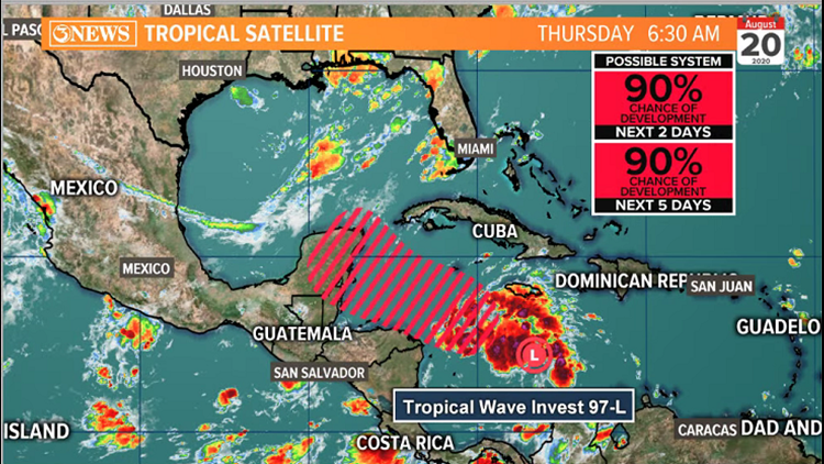
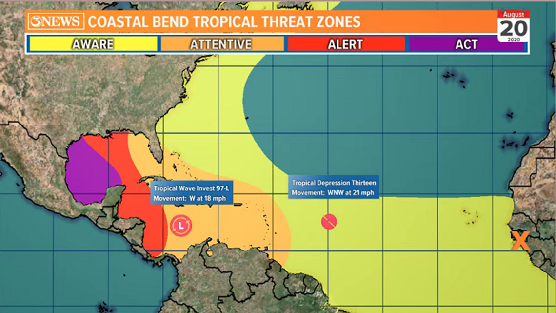
There are currently three systems in the tropics - Invest 97L, Tropical Depression 13, and another tropical wave about to come off of Africa. Invest 97L is the system that needs to be monitored the most closely for possible impacts on the Coastal Bend. Although, Tropical Depression 13 will likely develop quicker and become stronger than Invest 97L down the road.

Lets focus on Invest 97L. The tropical wave will likely develop by the weekend in the Western Caribbean as it approaches the Yucatan Peninsula. The National Hurricane Center is giving it a high (90%) probability to develop within the next 5 days. The forecast isn't to difficult to reason for the Caribbean part of this storm's progression - it's what happens after, that becomes murkier.

Depending on how Invest 97L interacts with the Yucatan, will shed light on the future of this system. Typically, when tropical systems are unorganized and they interact with land, they can move back over water and develop without hesitation. But when storms are organized, move over land and fall apart, they tend to have more difficulty regathering themselves over water...at least in the short term. That being said, with Invest 97L in the developing phase, it's future will depend on the structure of it over the Yucatan.
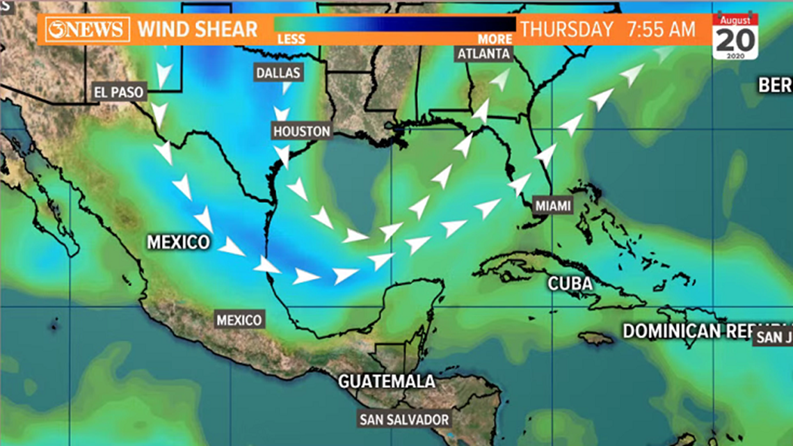
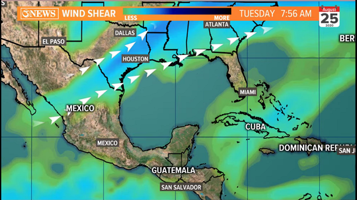
Something else to consider - wind shear. A trough in the jet stream currently over the SE US is promoting a healthy amount of wind shear in the Western Gulf. That trough is expected to lift north by early next week, about the time Invest 97L, or whatever it's deemed at that time, moves in to the Western Gulf. I attached the wind shear today vs. next Tuesday for comparison below.


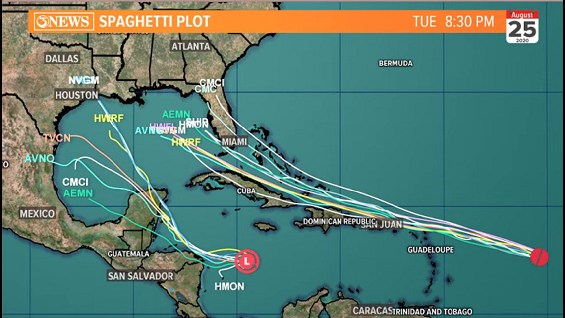
So, what's to come AFTER the Yucatan? That's the million dollar question. Forecast guidance is widely varied on track, but somewhat in agreement on Intensity. The spaghetti plot on Invest 97L spreads from anywhere between Louisiana and Mexico, moving in on Tuesday of next week. I expanded the view out to include Tropical Depression 13, which is forecast to bend north in the Central or Eastern Gulf, or even toward Florida early/middle next week.

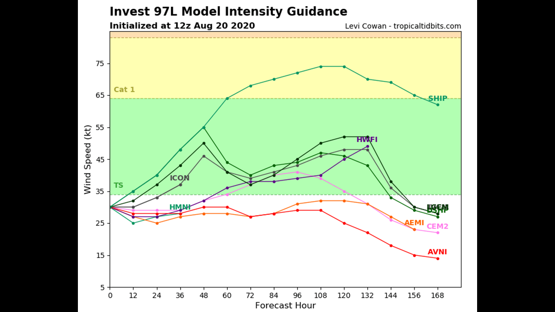
With respect to intensity - this answer is far from known. Thursday morning suite of data indicates that most of the reliable forecast models agree Invest 97L stays below hurricane force. The main reason for that is the forward speed. It's not going to have a huge amount of time in the western Gulf (maybe 2 or 2.5 days) to develop before it moves in to wherever it tracks. Other mitigating factors will not be there. Wind shear looks like it'll be favorable, waters are plenty warm, and there isn't much dry air in front of it. Time is the biggest limiting factor. Below is the forecast intensity guidance from this morning.

To wrap it up, Invest 97L is the feature to watch for the Coastal Bend. It will likely develop into the weekend and then cross the Yucatan. As it emerges in the Western Gulf, possible forecast track extends from Louisiana to Mexico, moving in on Tuesday. Intensity forecast is TBD. I'm not ready to make my forecast bed just yet as this system has not yet developed. Be sure to stay up to date with the latest forecast trends and information as this storm evolves. Summary of the two storms headed for the gulf, below.

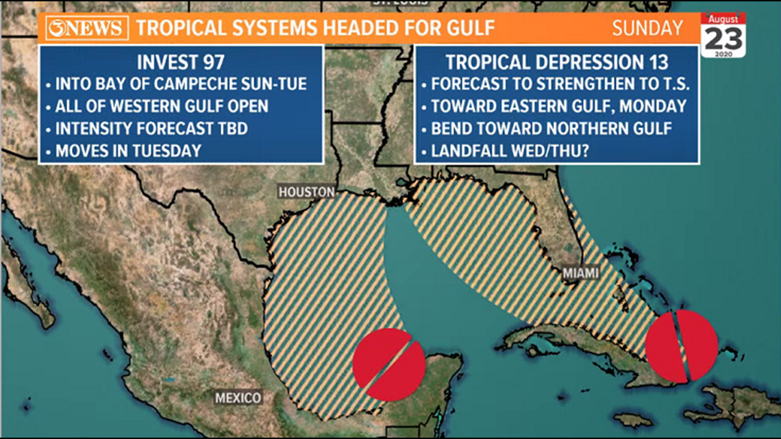
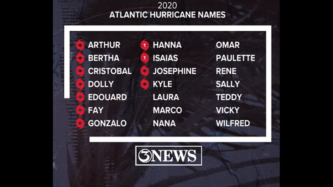
Next two names up on the list are Laura and Marco. Names on these systems will depend on which one reaches tropical storm status first. So, most like, TD 13 will be Laura and if Invest 97L can get there...that would be Marco.

- Holt, out