CORPUS CHRISTI, Texas —
LATEST FORECAST
7am (Sept. 22) Tropical Update - Beta
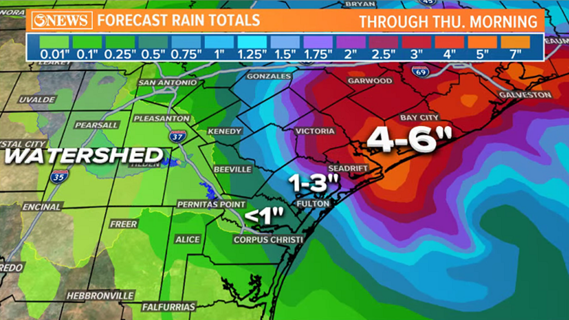
Corpus Christi and points to the north, east of HWY 77 have received between 1 and 2 inches of rain over the last 36 hours. Higher totals closer to the center of Beta. Unfortunately, the watershed will not benefit much from Beta's rainfall.
Wind reports from Beta show mid to low end tropical storm force near landfalling locations; as high as 52mph in Victoria. 37mph at Corpus Christi NAS...just below tropical storm force.
4AM (Sept. 22) Tropical Update - Beta
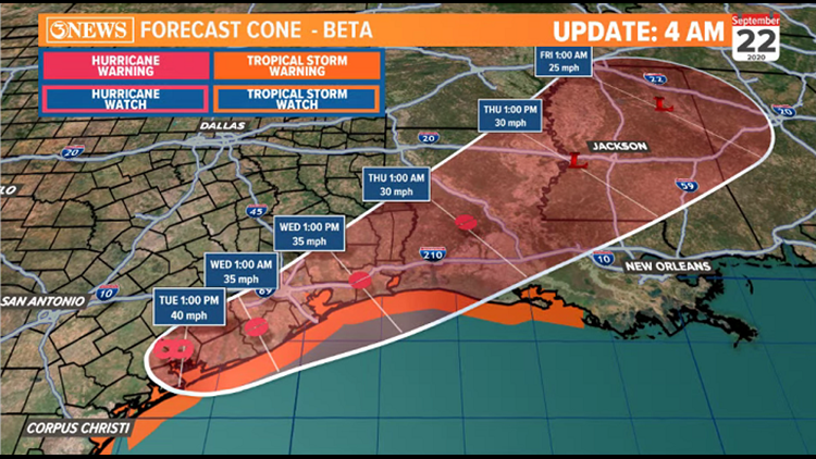
After moving ashore around 10PM last night near Port O'Connor, Beta has retained its tropical storm status; but just barely, with 40mph sustained winds. The center of the storm is sitting near Victoria.
Beta will linger in the middle Texas Gulf Coast area today, then pick up forward momentum and move northeast. The placement this morning will translate to some passing showers for the Coastal Bend. Overall, effects will be lower than what was observed yesterday - which wasn't much.
The back side of barrier islands and locations with bodies of water directly north or west may still have some water piling in, thanks to the NW winds, but this also will not be as much as yesterday.
Beta will lift north and become a tropical depression into Wednesday and Thursday.
- Holt, out
10AM (Sept. 21) Tropical Update - Beta
Beta remains a 50mph tropical storm, struggling with dry and and wind shear. The storm is moving west/northwest at 7mph and is about 50 miles away from the middle Texas Gulf Coast.

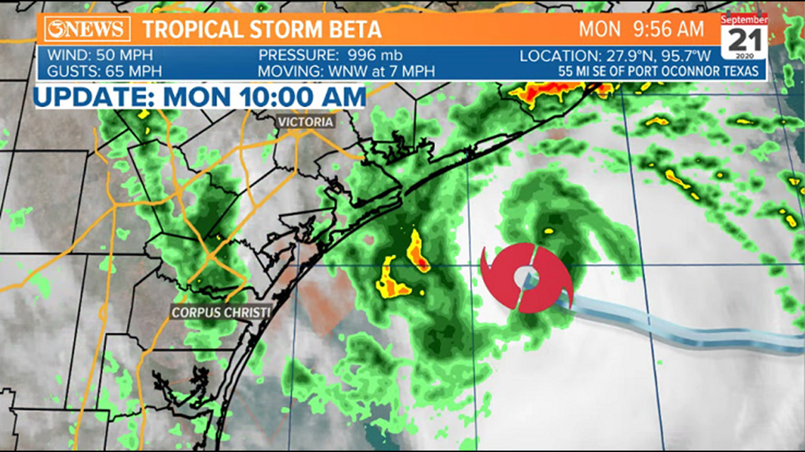
Beta will make landfall between san Antonio and Matagorda Bays this evening, around 7pm as a 50mph tropical storm. Rockport and Refugio are both inside the cone; although, impacts won't be dramatically different even if Beta slides a little farther south. the storm stalls over the middle Texas coast Tuesday before moving northeast Tuesday afternoon and Wednesday. That's when weather in the Coastal Bend will improve.

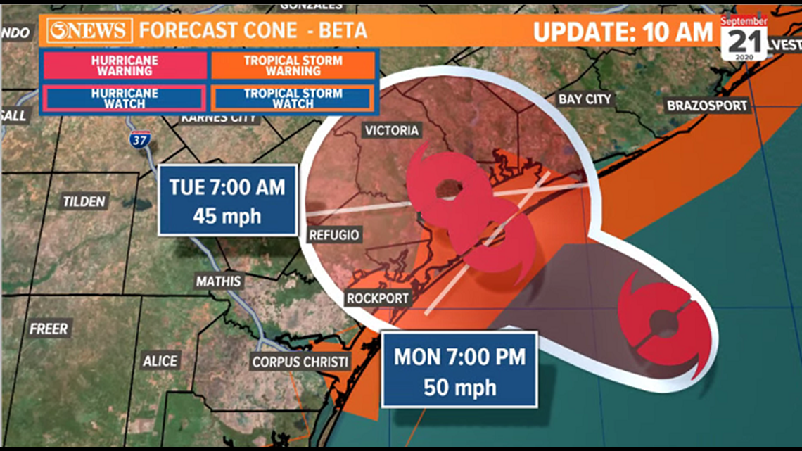
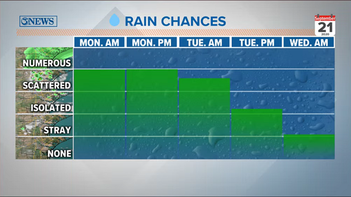
We're already seeing the rain around Beta's outer bands move through the Coastal Bend. 1-3" of rain will be possible near the coast and east of I-37, with less than that to the west.

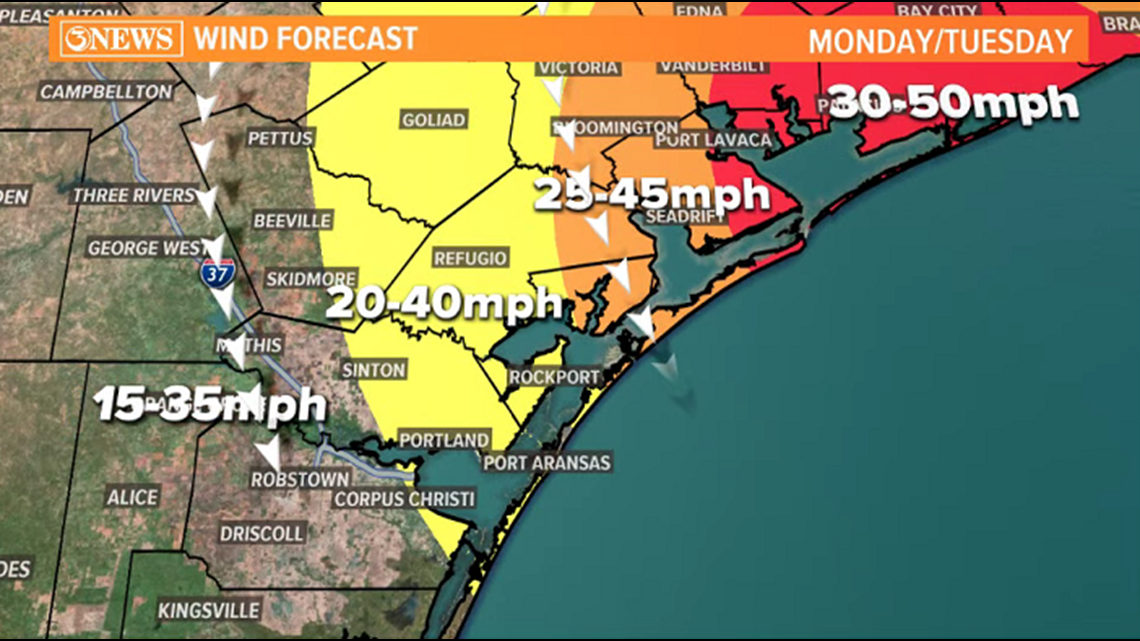
Winds will stay below tropical storm force for much of the area, but some locations east of I-37 may receive low end tropical storm force conditions. Tropical Storm force starts at 39mph.
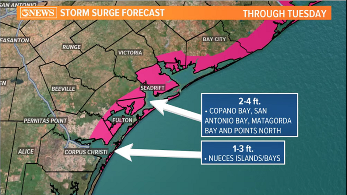
Storm surge will run 1-3ft. in Nueces County and 2-4 ft. in Aransas County. This will inundate lower lying, flood prone areas and beaches. A note on the storm surge with Beta. Compared to Hanna, this is a lower surge forecast. But because winds are out of the NW, the back side (bay side) of area barrier islands will likely receive a higher rise in water than what was received with Hanna.
4AM (Sept. 21) Tropical Update - Beta
Tropical Storm Beta is a storm struggling to overcome dry air and wind shear. Because of those two things, Beta has not been able to strengthen and has weakened a little this morning - Now producing 50 mph sustained winds. Beta is moving west at 6 mph, roughly 100 miles away from the TX Gulf Coast.

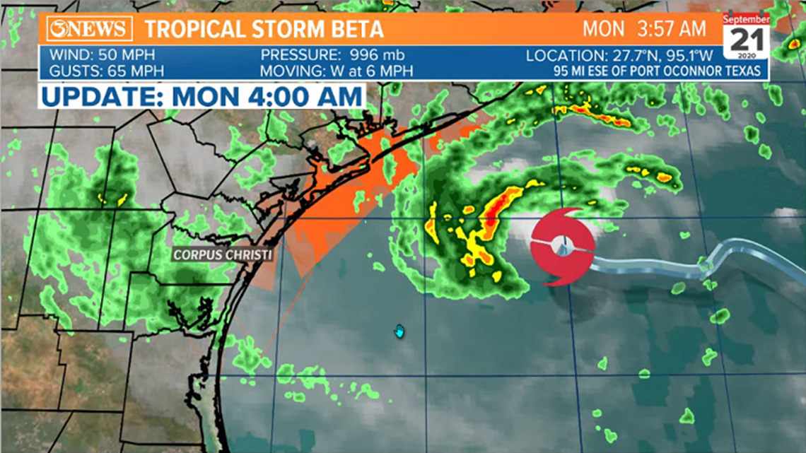
Beta is forecast to move ashore tonight between San Antonio Bay and Matagorda Bay as a 45-50 mph tropical storm. Then the storm moves northeast and weakens further as it tracks up the Texas coast Wednesday and Thursday.

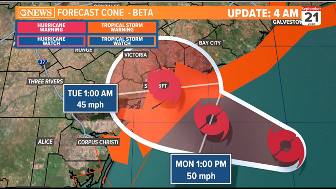
Effects in the Coastal Bend will be minor from a rain and wind perspective but storm surge is creating some flooding issues on area beaches and low lying coastal areas. 1-3 ft of storm surge in Nueces County and 2-4 ft. of surge in Aransas County is flooding area beaches. Because of the changing beach landscape from Hanna and Laura, previously this year, flooding looks a bit more problematic at the beach. Places like North Beach, Laguna Shores, and the parking lot near Virginia's in Port Aransas are all inundated.

We've already had some of the outer bands of rain pass through the area this morning and rain will be occasionally passing through the area today and tomorrow. While flooding rains are not expected locally, Some locations may receive a few inches of rain over the next few days, locally. Higher totals in the middle and NE Texas coast.

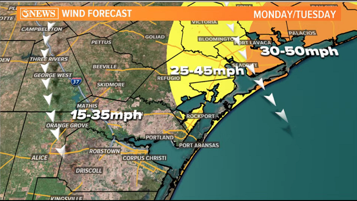
Winds will be low end tropical storm force. Locations most likely to receive low end tropical storm force winds are all east of I-37. I don't see any location in the viewing area exceeding 50 mph Monday or Tuesday.

As Beta moves north, weather conditions will gradually improve, starting late Tuesday, into Wednesday.
-Holt, out
10PM SUNDAY UPDATE
10 PM SUN UPDATE - Tropical Storm Beta continues to track west-northwest at 6 MPH tonight. Forecast track continues to move towards Matagorda Bay through Monday. However, Rockport is now technically inside the forecast cone. Moreover, on the outer western edge. Something to monitor through tomorrow is the track of Beta and whether it is slightly farther south tomorrow morning.
4 PM SUNDAY UPDATE
Tropical Storm Beta showed some giddy up this afternoon with a burst of convection (storms) south of the center of the storm, but was short lived, and has since settled down. Beta remains a 60mph tropical storm, just as it has the last two days.
10AM SUNDAY UPDATE
Beta continues to struggle, ingesting dry air and taking on wind shear, courtesy the weak cold front stalled in the gulf. That front is why it feels great outside, btw. Tropical Storm Beta is maintaining its 60mph winds that it has over the last 24 hours and is moving WNW at 3mph. High pressure over Arkansas/Missouri will guide Beta west.

10a cone has narrowed on the Central Texas Gulf Coast, slightly north of Matagorda Bay through landfall Monday evening as a 60mph tropical storm. Beyond landfall, a sharp north or northeasterly movement is expected as a trough moves through the central US and pulls the system north. You can see how wide the cone becomes through Thursday.
With a mid-grade tropical storm moving in to the Central Texas Gulf Coast, effects will be minor for the Coastal Bend. Most locations will stay BELOW tropical storm force (39mph), with only parts of Aransas and Refugio Counties (in the KIII viewing area) possibly getting low end tropical storm force conditions. Points north and east of that have a better chance.

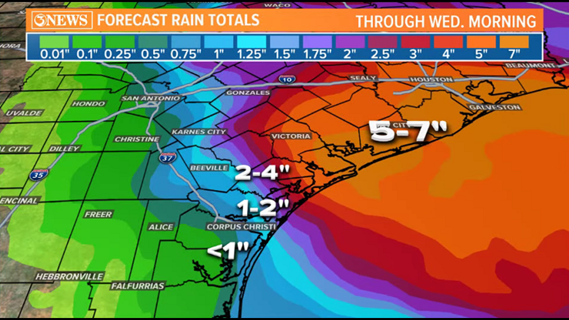
A track like this also keeps rainfall accumulations low. It's probable that less than an inch falls in Corpus Christi. If a rain band can wrap around the back side of the system, it would be nice, but overall, the rain outlook is not great, locally, with this the forecast track. Near a half a foot possible in SE TX. A much different outlook than the thinking last Friday. This is why high uncertainty was expressed, then.
Storm surge on area beaches will be between 1-3ft. in Nueces/Kleberg Counties and 2-4 ft. in Aransas County and northward. This is enough for coastal flooding and water up to the dunes through landfall and maybe into Tuesday.
8AM SUNDAY UPDATE
Storm surge warnings extend as far south as the Nueces County barrier islands, where 1-3 ft. of surge inundation is forecast. 2-4 ft. for Copano, San Antonio, and Matagorda Bays - and points to the north.
This isn't a huge storm and with a passage north of the Coastal Bend, off-shore northerly winds could mitigate some of the surge. I put a transparent, hypothetical placement of a storm to illustrate how winds would flow around a storm passing north of the area.
Flood prone areas (like North Beach in Corpus Christi) may see some inundation. I've seen photos from the spot by Virginia's in Port Aransas that also has some water in it already. It'll be places like that with surge inundation. 1-3 ft. Will put water up to the dunes on area beaches.
For perspective, Hanna, in July, had 3-6 ft. of surge with onshore easterly winds as the storm moved in south of Corpus Christi.
Minor coastal flooding will be the biggest problem on our end from Tropical Storm Beta. Coastal flood warnings in effect through Monday as poor driving conditions will persist along our coastline.
As Tropical Storm Beta continues to track closer to the northeast through Tuesday, the rain and wind threat has lessened as we look to be on the "drier" side of things. Still some scattered rain for Monday and minor coastal flooding at the beaches. However, heavier rainfall and storm surge is expected closer to Houston.
4AM SUNDAY UPDATE
Tropical Storm Beta continues slowly to the west-northwest at 3 MPH.
MAX winds at 60 MPH. Still interacting with a lot of dry air and disorganized.
The forecast cone has shifted to the northeast leaving Corpus Christi OUTSIDE of the cone. The trend is the storm to move farther northeast meaning forecast rain totals have trended down. Monday will be our best chance as the storm moves closer to Houston.
10:30PM SATURDAY UPDATE
Tropical storm Beta is having a rough go of it and hasn't moved much today. It's still about 300 miles away from Corpus Christi and is producing 60mph winds. It has a slow NE drift at 2 mph.
Tropical Storm Beta will eventually begin to work to the west, toward the Texas Gulf Coast. Dry air in its path (thank you weak cold front and thank you for how nice it felt outside today) will mitigate strengthening on its westward path over 36-48 hours. Intensity forecast has decreased - a 60 mph tropical storm, tops. The forecast cone brings Beta in slightly earlier than previous update - around 7pm, Monday. The forecast cone also is a bit more focused on the Central Texas Gulf Coast, centered on Matagorda Bay. Notably, Corpus Christi is now outside of the forecast cone.
I still think tropical storm force winds could extend as far south as the Corpus Christi area and near the I-37 corridor, but these will be low end tropical storm force conditions with winds in the 40 mph range. Higher winds toward the Matagorda Bay area, but all locations staying below hurricane force. I adjusted the hand drawn wind map - also attached in post.
The flood threat has gone way down in the Coastal Bend. With a storm passing north of the area, rain totals will likely be on the order of a few inches between Sunday and Wednesday. Higher values north of the center. Rain Map attached.
A storm passing north of the Coastal Bend will send northerly winds into the Coastal Bend which will mitigate max storm surge potential thanks to off-shore flow. Still, 1-3 ft. storm surge in coastal locations of Nueces/Kleberg County and a 2-4 ft. surge in coastal locations of Aransas County. Flood prone coastal areas and locations that typically observe flooding in situations like this will be inundated. For perspective, Hanna had a 3-6' Surge on Corpus Christi beaches.
9:30PM SATURDAY UPDATE
Depending on how far south the track of Tropical Storm Beta moves will determine more about rainfall Monday and Tuesday. Expect cloudy skies with scattered showers across South Texas to start off the week . Winds will start to pick up late Sunday and continue through Tuesday. After Tuesday, rain should back off and move northeast closer to Houston.
6PM SATURDAY UPDATE
Beta will struggle with intensification due to dry air moving in from the north. This should reduce the risk of rapid intensification over the next couple days as Beta continues to move west closer to the coast. Moreover, keeping it somewhat disorganized.
As Tropical Storm Beta strengthens through Monday, hurricane force winds will primarily be focused around its center which should be to the north of us early in the week. However, winds are expected to get gusty in the Coastal Bend Monday and Tuesday. Bring in any lawn furniture, outdoor belongings, etc.
Starting on Sunday, we'll begin to see more clouds move in from the gulf. Additionally, beach and surf conditions will deteriorate. Higher than normal tides, coastal flooding, 1-3 FT storm surge across the area, etc. Winds will start to pick up from the north through Sunday evening 20-30 MPH with higher gusts. Isolated showers will start to drive in late Sunday.
4 PM SATURDAY UPDATE
Tropical Storm Beta remains a 60mph storm sitting stationary in the gulf, about 300 miles east of Corpus Christi. Tropical Storm Warnings in Aransas/Refugio Counties and Tropical Storm Watches in San Patricio, Nueces, Kleberg, and Kenedy Counties.
10 AM SATURDAY UPDATE
Tropical Storm Beta remains a ragged looking storm with plenty of convection firing on the northern half of the storm. Within the last hour, new convection closer to the center has been noted. You can see that on satellite imagery. Beta has maintained 60 mph winds and is about 300 miles east of Corpus Christi. Also of note, a westerly turn has started - direction is now NW at 3 mph.
The forecast cone shows a strengthening storm, reaching hurricane status on Monday, just off the Texas Gulf Coast. The Hurricane Center does make note of the dry air ahead of this storm that it will have to overcome. They also admit that forecast models keep this storm below hurricane strength and their forecast intensity is above all model guidance... a downward adjustment in intensity may be in order this afternoon.
The forecast track and where the storm bends north is tricky because of some steering components at play (I'll post on this shortly), but the 10a cone does move the center of Beta over land, near Matagorda Bay on Monday night or Tuesday morning. Then a sharp northeasterly turn up the Texas Gulf Coast as a tropical storm through Thursday. It does look like the storm will stay north of Corpus Christi. But by how far is still in question. STAY UP TO DATE!
8:30 a.m. Saturday -- Join the LIVE Question and Answer session!
Tropical Storm and Hurricane Watches are posted in the Coastal Bend. These mean that tropical storm or hurricane conditions are POSSIBLE within the next 48 hours.
Tropical storm force = 39-73mph wind
Hurricane force = 74mph+
The wind field around tropical systems circulates counter-clockwise (cyclonic). With the current forecast track in mind, as Beta approaches the Texas Coast, winds will be generally out of the north in the Coastal Bend. This will mean storm surge isn't as bad in the Coastal Bend because the winds won't be pushing directly on-shore. That being said, it is possible that a 1-3 ft. surge takes place along the Coastal Bend.
To compare with Hanna, that storm moved in south of Corpus Christi, sending an easterly fetch of on-shore winds directly in to the area. That sent a 3-6 ft. surge in.
7AM Tropical Update - Beta
Some subtle changes in track will change how effects are delivered to the Coastal Bend.
Tropical Storm Beta is producing 60 mph winds in the Gulf of Mexico and is about 290 miles east of the mouth of the Rio Grande. Beta is still moving north at 8 mph, but is forecast to eventually turn west today.
Beta's forecast cone shows a northerly shift in its westward path toward Texas. Beta is also forecast to reach hurricane status on Sunday with 80 mph winds on Monday as it approaches the Central Texas Gulf Coast. Beta will be very close to a landfall on Tuesday morning, before veering northeast and running up the Texas Gulf Coast and weakening to a tropical storm Wednesday and Thursday.
Given how far north the storm currently is and because of the more northerly approach to Texas, the Coastal Bend may be south of center of the storm as it approaches. That will have an effect on how impacts are received locally.
WIND - I do think the Coastal Bend gets tropical storm force conditions (39-73 mph), but I do not think winds reach hurricane force, locally. The tropical storm force winds would happen on Monday and Tuesday.
RAIN - Mimicking the northerly shift on approach to Texas, the rainfall totals will also shift north a bit. Also, yesterday, the thought was to come in more from the south and parallel more of the coast...which would have delivered very high rain totals. With this forecast cone, rain totals will be lower in the Coastal Bend, but still notable. Some locations could get up to around a half a foot of rain.
More posts on impacts to come shortly.
4 a.m Saturday -- Beta's strength holds at same intensity since last update. Max winds at 60 MPH. Beta is currently moving NORTH at 8 MPH.
A Storm Surge Watch is in effect for... * Port Mansfield, TX to Cameron, LA including Baffin Bay, Corpus Christi Bay, Copano Bay, Aransas Bay, San Antonio Bay, Matagorda Bay, Galveston Bay, Sabine Lake and Calcasieu Lake
10 p.m Friday --
Hurricane Hunters find Tropical Storm has strengthened. Sustained winds at 60 MPH with 70 MPH gusts. Moving at a faster speed with track at NNE 12 MPH. Still expected to strengthen into a Category 1 hurricane.
Forecast cone has shifted slightly to the east and north. Corpus Christi continues to stay in the cone of uncertainty.
Hurricane WATCHES in effect from Rockport and NORTH
Tropical Storm WATCHES in effect from Corpus Christi and SOUTH
5 p.m. Friday -- Tropical Storm Beta forecast to to briefly reach category 1 hurricane status, then down to TS as it bends north, paralleling the TX Gulf Coast next week. For the Coastal Bend, prepare for flooding rains (could be over a foot) and tropical storm force conditions (39-73 mph winds).
There are two things on the chart - the probability of TS force winds (39-73 mph) at a given location, & the timing of when to expect them. For the coastal counties of the Coastal Bend, a 40-50% chance of TS force wind with the most likely arrival time being around 8A, Mon.
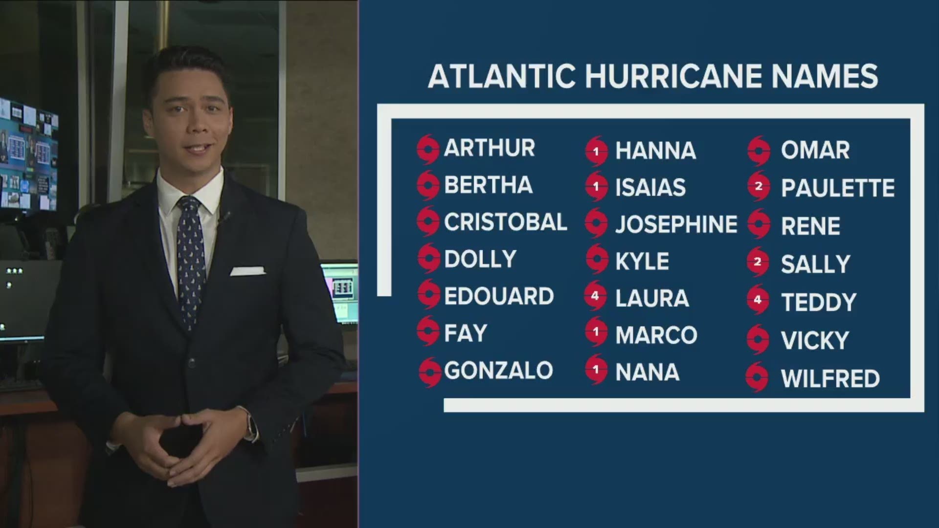
4 p.m. Friday - Tropical Storm Beta has officially formed in the Gulf of Mexico. Tropical Storm Alpha formed on the other side of the Atlantic Ocean earlier this morning. Max winds for Tropical Storm Beta are at 40 MPH as of the last update from the National Hurricane Center. We are into the Greek Alphabet.
A knowledge nugget on today's 3 storms becoming named - Wilfred, Alpha, Beta. This is the first time within a 24 hour period that three tropical storms have developed - ever. And it all happened within 6 hours today.
Noon Friday - Tropical Depression 22 stays just below tropical storm strength Friday morning, but may reach tropical storm status later today.
Forecast cone remains similar to last update, bringing this storm north, then bending west toward the Texas Gulf Coast over the weekend. While the storm may stay off-shore, it will likely pass close enough to deliver tropical storm force (30-50 mph wind) conditions to the coastal areas of the Coastal Bend Monday and Tuesday.
Heavy, flooding rains remain the biggest threat. Because of the high uncertainty in the forecast cone after the weekend -- note the nearly perfect circle of the cone Monday-Wednesday -- rainfall numbers will fluctuate a bit until more clarity is found into next week. That being said, this may end up being a big rain producer for a lot of the Texas Gulf Coast. Some model data has been suggesting a foot or more of rain for some.
RELATED: PINS closing access to South Beach at 8 a.m. on Sept. 19 in response to predicted coastal flooding

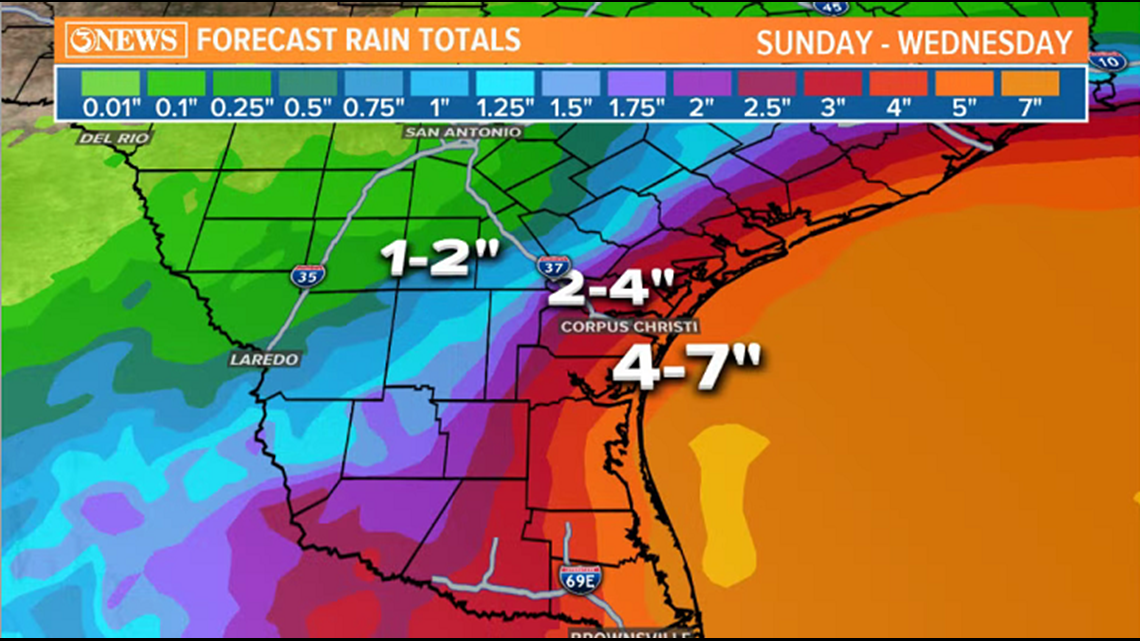

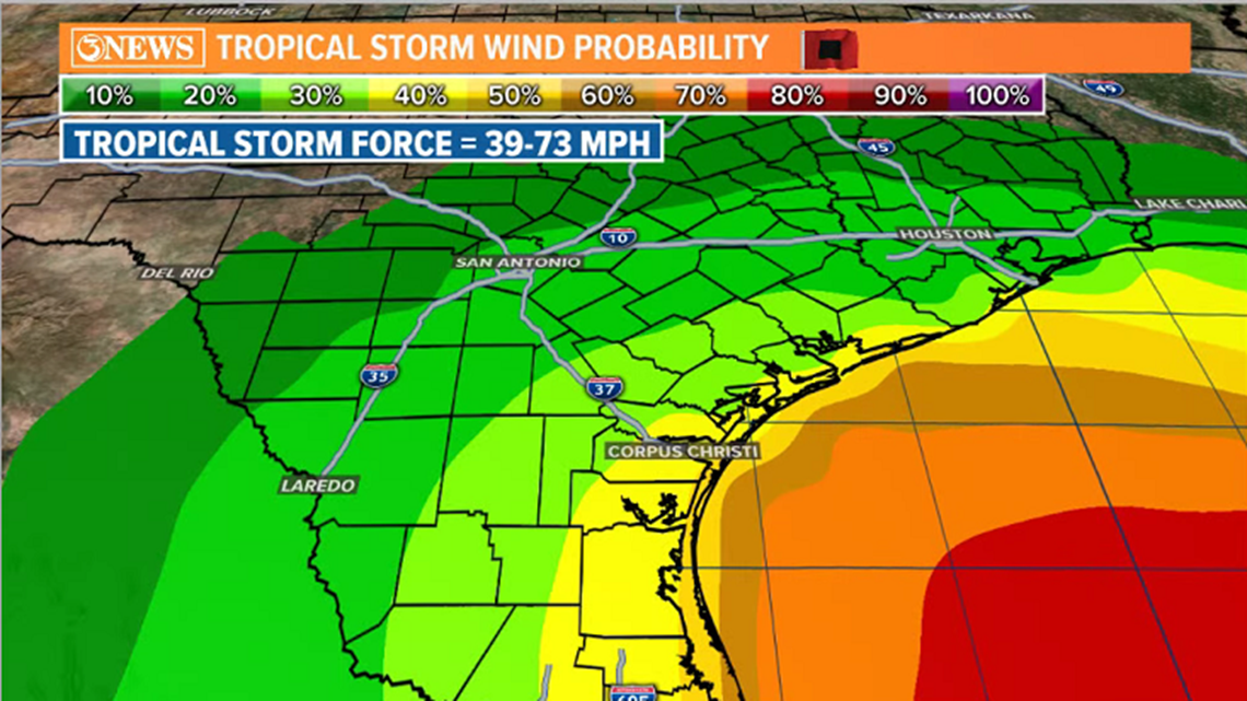
To stress, there is still high uncertainty into next week. Stay up to date with the most current forecast numbers as they will shift with the track.
~ Holt, out.
10:23 a.m. Friday - Tropical Depression 22 is in the Bay of Campeche this morning and has started moving in a north/northeasterly direction. It has 35 mph sustained winds, just below tropical storm status. TD22 will likely become a named storm on Friday.

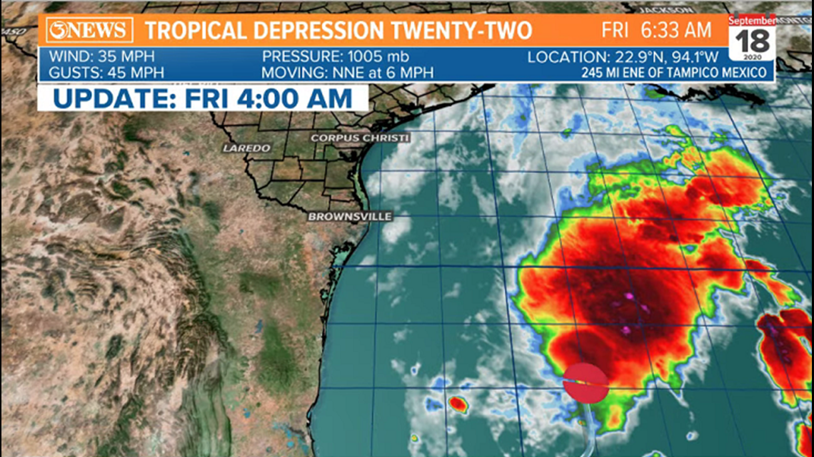

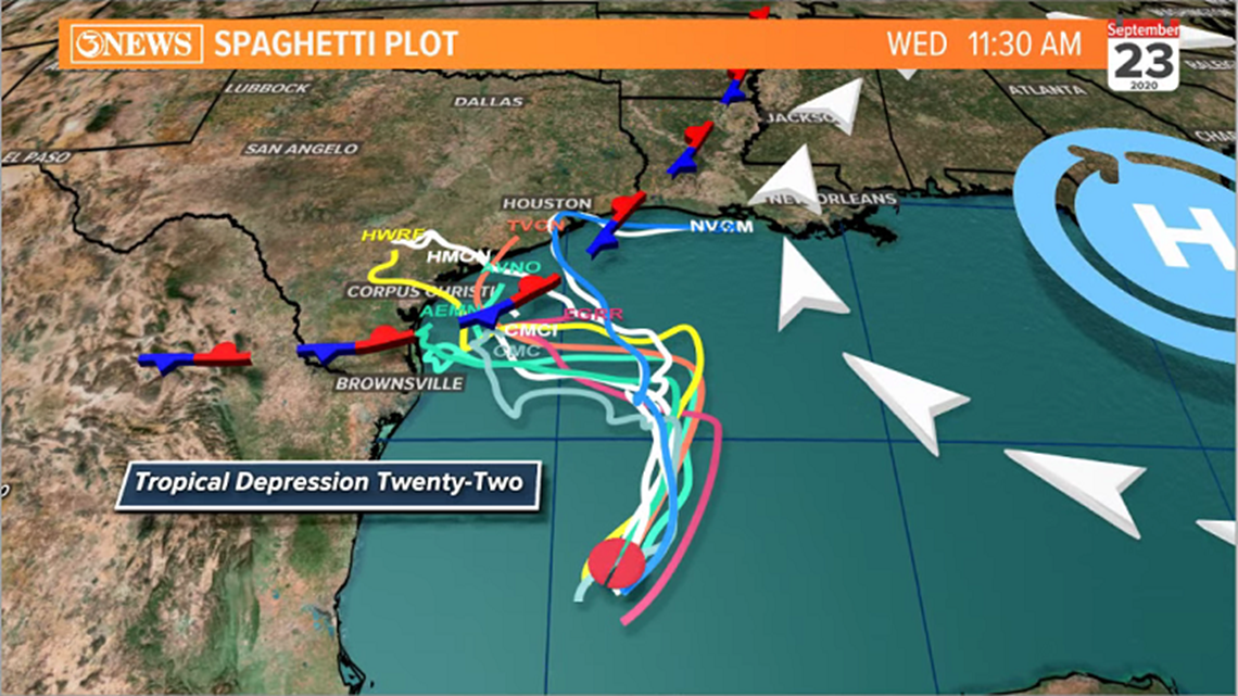
As this storm drifts north, it will be influenced by both high pressure over the southeastern US and a stalled cold front in the northwestern Gulf of Mexico. The storm will take its left (west) turn over the weekend as high pressure deflects it that direction. The stalled cold front will then introduce some wind shear and could throw some dry air at this system. We see the mitigating effects of the front and influence of the high pressure reflected in the NHC forecast cone.

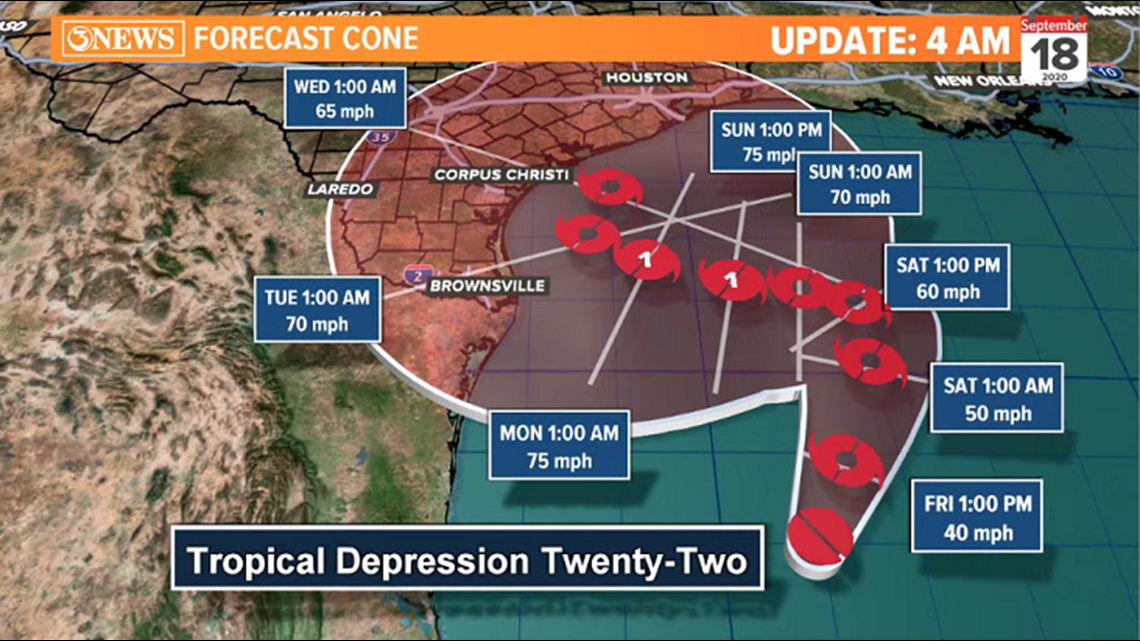
The current forecast cone brings TD22 to tropical storm status Friday and low end Category 1 hurricane status over the weekend. As the storm progresses slowly west, the storm is forecast to then weaken as it gets closer to Texas for the reasons mentioned above. There is HIGH UNCERTAINTY in the forecast cone after the weekend. See how the cone looks like a giant circle? That equals low confidence. Most, if not all forecast guidance is also suggesting a tropical storm. This is subject to change, though.

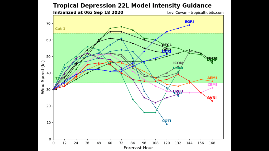
It is possible that the Coastal Bend experiences tropical storm force conditions into early next week. Keep in mind, tropical storm force is wind speeds of 39-73 mph. As of writing, 30-50 mph winds Monday/Tuesday seems plausible, given the current forecast track/intensity. That's something the Coastal Bend can handle.


The bigger threat for the Texas Gulf Coast will be heavy, flooding rains. Given the slow movement of this storm, high rain totals will be likely between Sunday and Wednesday. Admittedly, this rainfall outlook is modest and some forecast models are printing a lot more. As more confidence in the specific track/intensity emerges, we can up this outlook accordingly. I think it's very likely that some locations along the Texas Gulf Coast get up to around a foot of rain next week. Totals will drop sharply after you get about 20-30 miles away from the coast.


Remember, the forecast will change and get adjusted as more info becomes available and confidence grows in the forecast. The key message now is for awareness and to know what is possible. Tropical forecasts evolve on a daily, if not hourly basis and when you stop paying attention, those changes can seem drastic if you aren't keeping up. We will continue to update and refine the forecast through the duration of this storm. Stay updated!
~ Holt, out.


